
Vancouver, British Columbia--(Newsfile Corp. - April 22, 2026) - SALAZAR RESOURCES LIMITED (TSXV: SRL) (OTCQB: SRLZF) (FSE: CCG) ("Salazar" or the "Company") is pleased to announce that it has consolidated 100% ownership of the Santiago Project ("Santiago"), located approximately 37 km north of the city of Loja in Loja Province, southern Ecuador, and to provide a comprehensive update on the project's exploration history and forward strategy.
Santiago hosts a compelling copper-gold porphyry target beneath a near-surface epithermal system. A broad program of historical drilling, airborne geophysics, and recent surface sampling has collectively defined a coincident geochemical and geophysical anomaly measuring approximately 3 km by 2 km - with the core of the porphyry system interpreted to remain entirely untested at depth. With full ownership now established, Salazar is positioning Santiago as a key priority for its next phase of exploration.
| PROJECT SNAPSHOT | |
| Location | Loja Province, southern Ecuador |
| Concession Area | 2,350 hectares (single concession) |
| Ownership | 100% Salazar Resources |
| Target Type | Copper-gold porphyry with near-surface epithermal overprint |
| Anomalous Zone | ~3 km × 2 km (coincident geochemistry, geophysics & alteration) |
| Porphyry Core | Untested at depth - primary opportunity for future drilling |
EXPLORATION HIGHLIGHTS
Historical Drilling by Newmont (1998)
- Three shallow drill holes intersected significant Cu-Au mineralization within the lithocap, interpreted to overlie a porphyry system at depth:
- FUD-01: 323.09 m @ 0.23% Cu and 0.40 g/t Au (0.72% CuEq), including 10.80 m @ 0.58% Cu and 0.40 g/t Au (1.07% CuEq)
- FUD-02: 267.80 m @ 0.24% Cu and 0.43 g/t Au (0.76% CuEq), including 170.95 m @ 0.33% Cu and 0.55 g/t Au (1.00% CuEq)
- FUD-09: 295.17 m @ 0.22% Cu and 0.20 g/t Au (0.46% CuEq), including 67.86 m @ 0.79% Cu and 0.27 g/t Au (1.12% CuEq)
Airborne MobileMT Geophysical Survey by Adventus Mining (2019)
- A large, coherent low-frequency conductivity anomaly was identified beneath the lithocap, interpreted as a sulphide-rich porphyry system at depth.
- A complementary TMI-RTP magnetic low (~2 km × 1.5 km), encircled by areas of higher magnetic response, is consistent with magnetic mineral destruction from hydrothermal alteration.
Surface Sampling Program by Adventus Mining 2021-2022 (1,477 Samples)
- A combined Au-Cu geochemical anomaly of approximately 3 km × 2 km was defined, confirming and complementing historical results.
- Within the 599-sample anomalous core zone: 47% returned >250 ppm Cu (values to 0.9% Cu); 34% returned >0.11 g/t Au, with 45 samples exceeding 0.5 g/t Au and a maximum of 21.1 g/t Au.
- Alteration mapping (141 Terraspec samples and field mapping) confirmed quartz-alunite, phyllic, and propylitic assemblages - consistent with a preserved porphyry system.
Epithermal Targets - Española Vein (Historical Rock Chip Samples)
- 2.0 m @ 28.10 g/t Au and 231 g/t Ag
- 1.0 m @ 26.00 g/t Au and 242 g/t Ag
- 1.0 m @ 18.20 g/t Au and 252 g/t Ag
- 1.0 m @ 4.80 g/t Au and 442 g/t Ag
Why the Porphyry Remains Compelling
- All historical drilling tested only the near-surface lithocap - the porphyry core at depth has never been drill-tested.
- Geochemical and geophysical data define an anomalous vertical extent of approximately 500 m, from the surface lithocap to lowest copper anomalies on surface.
- 3D reinterpretation of all available datasets confirms the porphyry core remains open and accessible.
Next Steps
- Salazar will analyze all available technical information to develop a targeted exploration program and determine best strategy to realize value for shareholders.
CEO COMMENT
Fredy Salazar, President & CEO, commented:
"We are pleased to consolidate 100% ownership of the Santiago Project, which hosts compelling geological, geochemical, and geophysical indicators of a large-scale porphyry copper-gold system. With a strong foundation of historical drilling and recent surface work, we are well positioned to advance Santiago as a priority target. We are excited by the opportunity to test the depth potential of this system - a target that has never been properly drill-tested - and look forward to providing further updates as we develop our exploration strategy."
| TECHNICAL BACKGROUND ▼ FOR READERS WHO WANT THE FULL STORY |
LOCATION AND GEOLOGY
Santiago consists of a single concession totalling 2,350 hectares, located approximately 37 km north of the city of Loja in Loja Province, southcentral Ecuador.
The project sits geologically within the Western Cordillera of the Ecuadorian Andes, on the eastern margin of the Cangrejos-Zaruma Intrusive Belt¹. Volcanic formations of the Saraguro Oligocene formation - comprising andesitic and dacitic lavas and tuffs intruded by granodioritic dikes - characterize the local geology. The alteration and mineralization assemblage is indicative of a medium- to high-sulphidation epithermal system, exhibiting intense alunite-quartz alteration and surrounded by mesothermal structures enriched in gold and silver. These structures appear to overlie a potential deeper Cu-Mo porphyry system at an estimated depth of 200-700 m. Evidence suggests that the gold mineralization is transitional between the porphyry and epithermal systems².
HISTORICAL SUMMARY
Exploration at Santiago began under a 1964 agreement between the United Nations Development Program and the Government of Ecuador, with regional work conducted between 1970 and 1972 across an 8,328 km² area. Early exploration identified copper-molybdenum stream sediment anomalies near Fierro Urco, along with mineralized intrusive rocks hosting gold, silver, zinc, and lead.
Subsequent work by Prospection Panama S.A. (1971-1981) included geochemical surveys, geophysics, and limited drilling (summarized in Table 1). Results confirmed broad zones of copper mineralization but were not followed up after concession expiry.
Table 1: Historical Prospection Panama Drilling Results
| Drill Hole | From (m) | To (m) | Thickness (m) | Cu (%) | Au (g/t) | Approx. True Thickness (m) |
| M01 | 43.58 | 80.77 | 37.19 | 0.18 | - | N/A |
| M06 | 99.36 | 109.42 | 10.06 | 0.21 | - | N/A |
| M07 | 33.53 | 124.97 | 91.44 | 0.16 | - | N/A |
| M08 | 85.34 | 327.76 | 242.48 | 0.23 | 0.3* | N/A |
| M09 | 31.56 | 151.79 | 120.21 | 0.26 | 0.3* | N/A |
| M10 | 3.96 | 151.17 | 147.21 | 0.36 | 0.3* | N/A |
| M11 | 3.66 | 185.93 | 182.27 | 0.12 | 0.3* | N/A |
Notes:
(1) The results in Table 1 represent currently available historical data. The Company has not verified the data; investors should not place undue reliance on it. Future exploration programs will include historical data verification.
(2) No original drill core or records are available for Prospection drilling; results are summarized in a Minera Climax del Ecuador report, September 1996.
(3) Drill holes M2, 3, 4, and 5 did not yield significant results.
(4) Gold assay results (*) appear to report below detection limits (0.3 g/t Au) or were not assayed for (-).
(5) It is unclear what QA/QC measures Prospection undertook; it is believed that industry best practices of the time were observed.
(6) Approximate true thickness cannot be estimated, as this is an early-stage project.
From 1982 to 1991, PREDESUR carried out additional exploration focused on identifying a porphyry copper system through sampling and geological mapping, though no drilling or geophysical surveys were completed. In the early 1990s, Ag Armeno Mines & Minerals acquired the concession and partnered with other companies, including Newmont and Pactech.
Newmont's work (1993-1994) targeted an epithermal gold system, identifying a large gold anomaly supported by extensive sampling and geophysical surveys. Despite drilling over 4,500 metres and intersecting wide zones of low-grade mineralization (Table 2), results did not meet expectations for a Yanacocha-style deposit, leading to Newmont's withdrawal. Importantly, this program tested only the shallow lithocap - the porphyry source at depth was never the focus and remains undrilled.
Table 2: Historical Newmont Drilling Results
| Drill Hole | From (m) | To (m) | Thickness (m) | Cu (%) | Au (g/t) | CuEq%(4) | Approx. True Thickness (m) |
| FUD-01 | 0.61 | 323.70 | 323.09 | 0.23 | 0.40 | 0.72 | N/A |
| Including | 127.65 | 138.45 | 10.80 | 0.58 | 0.40 | 1.07 | N/A |
| Including | 188.65 | 209.90 | 21.25 | 0.65 | 0.18 | 0.87 | N/A |
| FUD-02 | 32.20 | 300.00 | 267.80 | 0.24 | 0.43 | 0.76 | N/A |
| Including | 129.05 | 300.00 | 170.95 | 0.33 | 0.55 | 1.00 | N/A |
| FUD-07 | 1.52 | 300.22 | 298.70 | 0.08 | 0.17 | 0.29 | N/A |
| FUD-08 | 3.05 | 300.23 | 297.18 | 0.12 | 0.23 | 0.40 | N/A |
| Including | 158.68 | 169.16 | 12.48 | 0.61 | 0.27 | 0.94 | N/A |
| FUD-09 | 5.06 | 300.23 | 295.17 | 0.22 | 0.20 | 0.46 | N/A |
| Including | 152.59 | 300.23 | 147.64 | 0.41 | 0.21 | 0.67 | N/A |
| Including | 213.39 | 281.25 | 67.86 | 0.79 | 0.27 | 1.12 | N/A |
| FUD-10 | 2.12 | 199.61 | 197.48 | 0.10 | 0.17 | 0.31 | N/A |
| Including | 74.11 | 199.61 | 125.50 | 0.14 | 0.21 | 0.40 | N/A |
| FUD-11 | 181.36 | 300.22 | 118.86 | 0.18 | 0.12 | 0.33 | N/A |
| Including | 240.37 | 298.02 | 57.65 | 0.28 | 0.14 | 0.45 | N/A |
| FUD-15 | 1.22 | 72.28 | 71.06 | 0.09 | 0.39 | 0.56 | N/A |
| Including | 24.67 | 33.95 | 9.28 | 0.05 | 1.49 | 1.86 | N/A |
| FUD-16 | 29.75 | 140.29 | 110.54 | 0.09 | 0.31 | 0.47 | N/A |
| Including | 44.53 | 55.68 | 11.15 | 0.31 | 1.10 | 1.65 | N/A |
| FUD-17 | 2.43 | 150.00 | 147.57 | 0.20 | 0.23 | 0.48 | N/A |
| FUD-18 | 10.97 | 106.87 | 95.90 | 0.07 | 0.39 | 0.54 | N/A |
| Including | 34.33 | 59.26 | 24.93 | 0.06 | 0.91 | 1.17 | N/A |
| FUD-19 | 3.04 | 115.82 | 112.78 | 0.08 | 0.18 | 0.30 | N/A |
| FUD-21 | 3.65 | 94.48 | 90.83 | 0.15 | 0.25 | 0.45 | N/A |
| FUD-23 | 53.75 | 400.50 | 346.75 | 0.12 | 0.23 | 0.40 | N/A |
Notes:
(1) Results in Table 2 represent currently available historical data. The Company has not verified the data; investors should not place undue reliance on it. Future exploration programs will include historical data verification.
(2) No original drill core or records are available for Newmont drilling; results are summarized in a Minera Climax del Ecuador report, September 1996.
(3) Drill holes FU-03, 04, 05, 06, 12, 13, 14, 20, and 22 did not yield significant results.
(4) Metal equivalency based on US$12,359.50/tonne Cu and US$4,672.68/oz Au (LME long-term pricing, March 7, 2026). No adjustments were made for metal recovery, as this is an early-stage project.
(5) It is believed that industry best practices of the time were observed for sample collection and analysis.
(6) Approximate true thickness cannot be estimated, as this is an early-stage project.
Subsequent work by Pactech and Minera Climax refined the geological interpretation, suggesting structurally controlled mineralization extensions. After a period of inactivity, the project was revived in 2005 by Mariana and subsequently acquired by Salazar Resources in 2010 (Map 1). Renewed work emphasized favourable geology, extensive hydrothermal alteration, and mineralized vein and breccia systems, with sampling of sulphide-bearing structures confirming significant gold and silver values.
In 2018, Salazar and Adventus Mining included Santiago in a country-wide exploration alliance ("Alliance"), 80% owned by Adventus and 20% by Salazar. The Alliance completed an airborne Mobile MagnetoTellurics ("MobileMT") geophysical survey over Santiago at 150-metre line spacing. Results defined a low-frequency apparent conductivity anomaly and resistivity anomaly of approximately 3,000 by 2,000 metres, accompanied by a TMI-RTP magnetic low of approximately 2,000 by 1,500 metres, encircled by areas of higher magnetic response - the magnetic low being suggestive of magnetic mineral destruction from hydrothermal alteration.
The Alliance then worked to validate these historical anomalies and preliminary targets through the 2021-2022 field program. By the end of 2021, 1,053 rock samples were collected (see December 7, 2021 press release), which provided enough information to produce lithological and alteration maps (Map 2 and Map 3). Following completion of that campaign in 2022, activities at Santiago were limited as the Alliance prioritized advancement of the El Domo Project. During this period, work focused on maintaining site access and road improvements, which remain in good condition for future programs.
2021-2022 EXPLORATION PROGRAM
The program carried out under the Adventus Mining / Salazar Resources Exploration Alliance focused on validating historical results and refining drill targets, as proposed in the June 15, 2020 press release.
- Systematic rock chip sampling was conducted on a 100 m × 100 m grid, with infill to 50 m × 50 m spacing in anomalous areas.
- A total of 1,477 samples were collected. Sampling was conducted in lieu of soil surveys due to the absence of soil cover in the area.
- Results defined: a gold anomaly (>0.11 g/t Au) covering ~2 km × 1 km, adjacent to a copper anomaly (>0.02% Cu) covering ~1 km × 0.8 km. Across all 1,477 samples, 23% returned >250 ppm Cu (values to 0.9% Cu) and 17% returned >0.11 g/t Au, including 45 samples with a minimum of 0.5 g/t Au and a maximum of 21.1 g/t Au.
- Alteration mapping (141 Terraspec samples and field mapping) confirmed quartz-alunite, phyllic, and propylitic assemblages consistent with a preserved porphyry system.
- Integration of results defined a 3 km × 2 km target area where porphyry potential is recognized, supported by coincident geochemistry, hydrothermal alteration, and MobileMT geophysics. Within this anomalous core area, 47% of the 599 representative samples returned >250 ppm Cu and 34% returned >0.11 g/t Au (Map 4).
QUALITY ASSURANCE AND QUALITY CONTROL
Samples from the 2021-2022 exploration program were submitted to Bureau Veritas Mineral Laboratories-Perú, an independent accredited laboratory. Samples were prepared and analyzed using a 45-element four-acid digestion ICP-MS method. Gold analysis was completed by lead collection fire assay fusion with AAS finish. Overlimit protocols are in place for gold, silver, copper, lead, and zinc.
The Company implemented a quality assurance and quality control (QA/QC) program incorporating the systematic insertion of certified reference materials (standards), blanks, and field duplicates, along with a documented chain of custody, to ensure the integrity and reliability of analytical results.
QUALIFIED PERSON
The technical content of this news release has been reviewed and approved by Kieran Downes, P.Geo., a Qualified Person as defined under National Instrument 43-101.
REFERENCES
1. Schutte, P. et al. (2012). Metallogenic features of Miocene porphyry Cu and porphyry-related mineral deposits in Ecuador revealed by Re-Os, ⁴⁰Ar/³⁹Ar, and U-Pb geochronology. Mineralium Deposita, 47(4), 383-410.
2. Sillitoe, R.H. and Hedenquist, J.W. (2003). Linkages between volcano-tectonic settings, ore-fluid compositions, and epithermal precious metal deposits. SEG Special Publication No. 10, 315-345.
ABOUT SALAZAR RESOURCES
Salazar Resources Limited is focused on creating value and positive change through discovery, exploration, and development in Ecuador. The team has an unrivalled understanding of in-country geology and has played an integral role in the discovery of many of Ecuador's major projects, including the country's two newest operating gold and copper mines. Salazar Resources maintains a wholly owned pipeline of copper-gold exploration projects across Ecuador, with a strategy to advance another commercial discovery and farm out non-core assets.
Salazar Resources actively engages with Ecuadorian communities and, together with the Salazar family, co-founded The Salazar Foundation, an independent non-profit organization dedicated to sustainable progress through economic development. At its maiden discovery, El Domo - Curipamba Project, Salazar Resources holds a 25% interest fully carried through to production. The Company now holds 100% ownership of the Santiago, Pijilí, Monja, Tigre, and Tarqui-Quimi exploration projects. For further information from Salazar Resources, please contact Nick DeMare, Director, at ndemare@chasemgt.com or at 604-685-9316. Please also visit the Salazar Resources website at www.salazarresources.com.
Neither the TSX Venture Exchange nor its Regulation Services Provider (as that term is defined in the policies of the TSX Venture Exchange) accepts responsibility for the adequacy or accuracy of this news release.
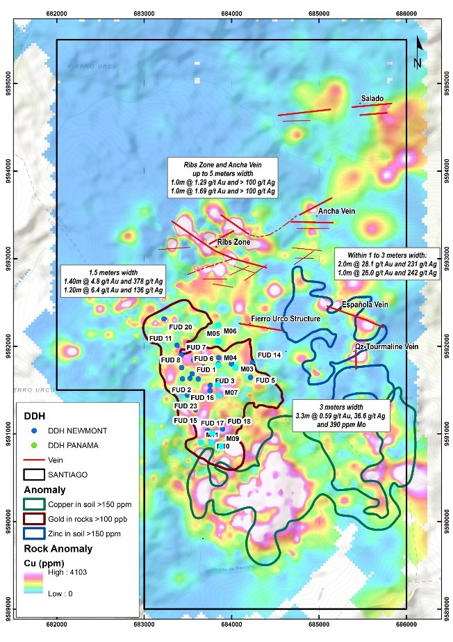
Map 1. Drill hole location and historical anomalies
To view an enhanced version of this graphic, please visit:
https://images.newsfilecorp.com/files/4631/293709_f1903ed604c79bd0_002full.jpg
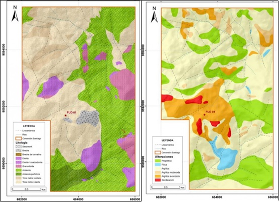
Map 2. Lithological Map Map 3. Alteration Map
To view an enhanced version of this graphic, please visit:
https://images.newsfilecorp.com/files/4631/293709_salazar1.jpg
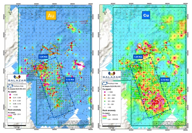
Map 4. Au and Cu Geochemical Anomalies (Historical-2022)
To view an enhanced version of this graphic, please visit:
https://images.newsfilecorp.com/files/4631/293709_salazar2.jpg
![]()
To view the source version of this press release, please visit https://www.newsfilecorp.com/release/293709